Tag Archives: Arizona Endurance series

Pleasantville

OLYMPUS DIGITAL CAMERA

When:
December 7, 2024  7:30am

Where:
We’ll be hosted by the #1 Trail Angel of the Tour Divide (Kirsten of the famed Brush and Mountain Lodge) who now has a home in Anthem, AZ and is letting us stage the ride from her casa – 2307 West Desert Hills Drive, 85086.

Parking: fill her front yard. Then overflow parking along 23rd Ave. Let’s try to keep Desert Hills Dr. clear this year.

Please bring a beverage & snacks to share for post-ride. Let’s show Kirsten how we roll here in AZ!!

What:
This is a big loop around Lake Pleasant – almost 60 miles. It will include some trail, some dirt roads and some other stuff. You may have to get slightly creative with routing on the north end of the lake – depending on lake levels. Same with riding along the Agua Fria. Could be “interesting” if the river is high.

Route:
As always, it is HIGHLY recommended that you bring, and know how to use, a GPS for this race. There will be no maps or cue sheets.

Pleasantville_route

Bonus: New for 2022 is a slight diversion (.3 miles down a dirt road) on the north side of the lake to to check out Solo Spring. Take a selfie at the spring and get a 20 minute bonus. Also, there is water behind that concrete wall – a couple of feet deep. Good for filtering if you are low.

Picketpost Punisher – Arizona Endurance Series

Picketpost Punisher

ppp

When:
November 16, 2024
The B (49 miles) and C (22 miles) routes will start at 7:30am. The A route (76 miles) will start at 5am.

Where:
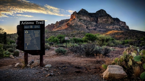
You will  start at the Picketpost trail head off of Route 60 near Superior, Arizona. This is about 60 miles east of Phoenix and about 5 miles west of Superior. If you pass the Boyce Thompson Arboretum, you’ve missed the trailhead turnoff. You can get directions to the start here.

The trailhead has pit toilets, but no water. Also no trash receptacles – pack it in, pack it out.

Camping is NOT allowed at the trailhead. There are however,  a bunch of places to primitive camp beside the road that leads to the trailhead.

What:
The Punisher will once again be split into 3 different lengths so that you can choose the amount of punishment you deserve. Make sure you review the GPS files.

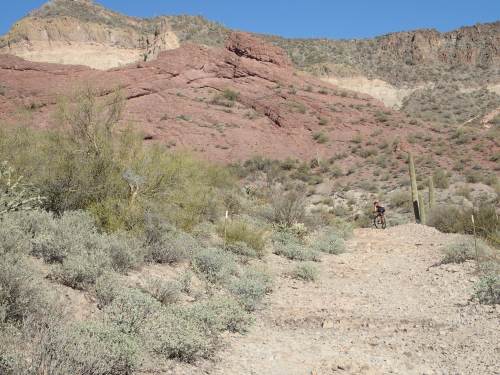
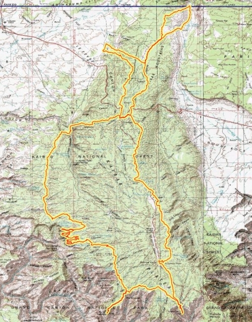
The C ride will be the shortest AES ride ever. A measly 22 miles and about 2300 feet of climbing. In place of FR4, you’ll get to ride new trails in Arnett Canyon. The route will climb on dirt roads part of the way up Montana Mountain. The descent back down will be on the Arizona Trail back to the Picketpost trailhead. Easy peasy.

The B ride is heading south this year. It is actually a subset of one of the previous year’s A route – without crossing the Gila River. You will head south on the Arizona Trail to FR4, then turn south on FR4 (it is not closed in this area). You’ll climb up on the ever lovely Telegraph Canyon road, then down, past Ajax Mine to Box Canyon. There will be a hard left to get you over to Martinez Canyon. After traversing the “brass knuckles” you’ll end up at the Gila River not far from the Arizona Trail. Filter water at the river, then head north to the AZT – all the way back to Picket Post.

The B ride has an opportunity for a time bonus. You’ll notice a little additional part of the route in Box Canyon. This goes to a section where the canyon gets very narrow – really cool to see. This is an out and back of about 3.75 miles. Do this and take a selfie. Your selfie, along with your GPS track, will get you an hour deducted from overall time.

The A ride (aka: The Pulverizer) will be the same stroll in the park as last year. You’ll begin by heading south on AZT down to the Gila River. You’ll cross the river (good chance to filter water) and start climbing to Florence-Kelvin Highway. You’ll then bomb down that dirt road all the way to Kelvin Bridge. From there it is AZT all the way back to the start.

READ THIS IF YOU ARE THINKING ABOUT DOING THE A RIDE:

The A ride is a seriously difficult ride. It is only for very experienced and capable back country endurance cyclists.  One of your sources of water is the Gila River – and that needs to be filtered. If you cannot meet the following criteria, don’t even bother:

1. You must have a GPS and know how to use it. There are no trail signs and it will be very easy to get lost.
3. You need to be prepared to be on your bike for 10-15 hours or more. Some VERY fast folks have done this in 10 hours. Expect it to take longer for most everyone else. 
4. You must have lights and be comfortable with riding at night in challenging terrain.

Water:
In a race of this length and remoteness, water is a concern. Bring as much as you can! We’ve done some scouting and found some possible and some dependable water sources. Water sources are marked (as waypoints) on the GPS files.

Route:
It is HIGHLY recommended that you bring, and know how to use, a GPS for this race. The Legends of Superior section has lots of areas where it is easy to miss the trail and get off course. Using a GPS and paying attention are the best ways to stay on course and not get lost. GPS files for all three courses can be obtained at the links below.
PPP_C_route
PPP_B_route(punisher)
PPP_A_route(pulverizer)

Kentucky Camp – Arizona Endurance Series

When:
November 2, 2024 at 9:00 am (9:15 start time for those doing the short course)

Where:
Kentucky Camp40 miles south of TucsonGoogle maps link here.

What:
There are two options for this race(1) a 29-mile lollipop or (2) a 46-mile figure 8. There will be camping available and a post-race party in the area for those that would like to grill. This year, we are doing the Kentucky Camp as a charity event for the Arizona Trail Association. If you want to ride and are not a member, please become a member here: https://aztrail.org/get-involved/join/ 

GPX files and maps:

Kentucky_camp_long_route

Kentucky_camp_short_route

For help uploading the GPX files to your GPS see: http://topofusion.com/tutorials/uploading-tracks.php

Using a GPS is highly recommended!

Kaibab 140 and 230 – Arizona Endurance Series

Date says June 1, But this in an ITT and the recommended dates are june- September

dave_hill_sm

What:
Your choice of one of two loop options (140 mile and 230 mile) on the fabulous Kaibab Plateau. While there is plenty of dirt roads there are also some awesome views of the west canyon (and a little of the east side) and amazing meadows north of the park border on the AZT. There is an optional, but totally worth it, out and back to Point Sublime.

When:
ITT. So you get to decide when you do it. Recommend June-September.

Where:  Here are the two options.

The main loop starts at Jacob Lake and follows mostly dirt roads to the north rim of the Grand Canyon. From there the route follows the Arizona Trail back to Jacob lake. This is a stout 2 days of riding, or a more reasonable 3 day route.

The other option adds in a loop to State Line campground. Both of these routes are worthy.

Route:
Kaibab_230_route

Kaibab_140_route

Export


Aspen Asphyxiation-Arizona Endurance Series

When:
At 8:00am on Saturday, June 1, 2024

Where:
Start/End at Fort Tuthill, big lot next to the Bike Park.

Where:
Aspen Asphyxiation is back in 2023 with a new route and new trails. We will start at Fort Tuthill and then shortcut through the city to Elden via Sinclair/AZT. We will then climb up the brand new Lower Brookbank and descend the gnarly Big Band/Afterglow. We will climb Dogfood and fire/flood survivors: AZT and Secret. We will connect via Freidlein Prairie Rd, Veit Spring Trail and Snowbowl Rd to Aspen Corner. From there it’s a fun descent on AZT and Moto. We will venture into the unknown by means of Hidden Hollow Road, Mesa Observatory forest service roads and A1 Mountain Rd. We will cross the railroad tracks via an interesting but straightforward solution. Then it’s on to Soggy Bottom Ranch Rd. to uncharted roads all the way to Rogers Lake Connector trail. Good ole FUTS and Soldier trail will take us back to Fort Tuthill.

Water available for filtering only in Shultz Creek and Roger’s Lake (and a number of small streams which may or may not still be there by next week).

VERY IMPORTANT:

Start time and route are provided here and it is up to the participant to understand the route, and also have full responsibility for their navigation and well being. Since the events are self-supportive, it should be understood that these are for experienced adult backcountry cyclists only. If you question your ability to complete such an event, it is best that you consider another option before trying one of these. Also, maps, gps devices, water filtration units, and other backcountry tools are methods to ensure you complete the race. Therefore it is up to you – and you alone – to ensure your safety!!

Route:
AA_route

Strava Cue Sheet:

2023 Cue Sheet

Sedona Big Friggin Loop – Arizona Endurance Series

When:
March 23ish, 2023 ITT: Choose your start time/day in order to avoid having too many bikers in one area. These trails have become VERY crowded, so we are trying to spread out and have different start times/days. 

Where:
We will be starting and finishing in Oak Creek Village. Notice that the start time has changed to a choose-your-own adventure style of riding. Disperse around Oak Creek Village for parking. Afterwards, there will be a BYOB in the parking lots near Bike-n-Bean and Red Agave.

The Route:
Sedona_BFL_route

If Oak Creek is running particularly high, this route can be used. Does require a $3 fee for Red Rock State Park. Sedona_BFL_alt_route

See TopoFusion’s Tutorial on uploading GPX tracks for help loading the GPX file onto your GPS.

Route Warning:
Due to the nature of this route, I strongly advise you to have a GPS with the GPX file loaded, and some of the maps below. Sedona is generally a well-marked area, nonetheless, as you will see, there are tons of trails that deviate from the trail (unmarked most of the time). I highly recommend that you either pre-ride the trail or consider take a GPS on the route. ESPECIALLY if you are a local and think you know the trails/route, you need a GPS. It’s the only way to be sure you ride the correct course. The route doesn’t necessarily take the most obvious or most ridden connections.